An R package for scientific maps of Alaska fisheries, modeled after the layer-based approach of quantifish/nzsf. Combine bundled sf polygons with ggplot2, retain agency area codes, and map the Aleutians continuously across the dateline.
Version 0.1.0: a reproducible cartographic reference, not a regulatory boundary product. Agency snapshots and analytical derivatives are identified separately. The package is independent of NOAA, ADF&G, and NPFMC and implies no endorsement.
Install
Show/hide R code
install.packages("remotes")
remotes::install_github("jimianelli/AKsf")
A private repository requires an authenticated GitHub token with access. From a local checkout, use R CMD INSTALL .. Installing from source requires the usual sf dependencies (GDAL, GEOS, PROJ, and UDUNITS); CRAN binaries include these on supported macOS and Windows installations. Maps use bundled data and need no network connection after installation.
Make a map
Show/hide R code
library(AKsf)
library(ggplot2)

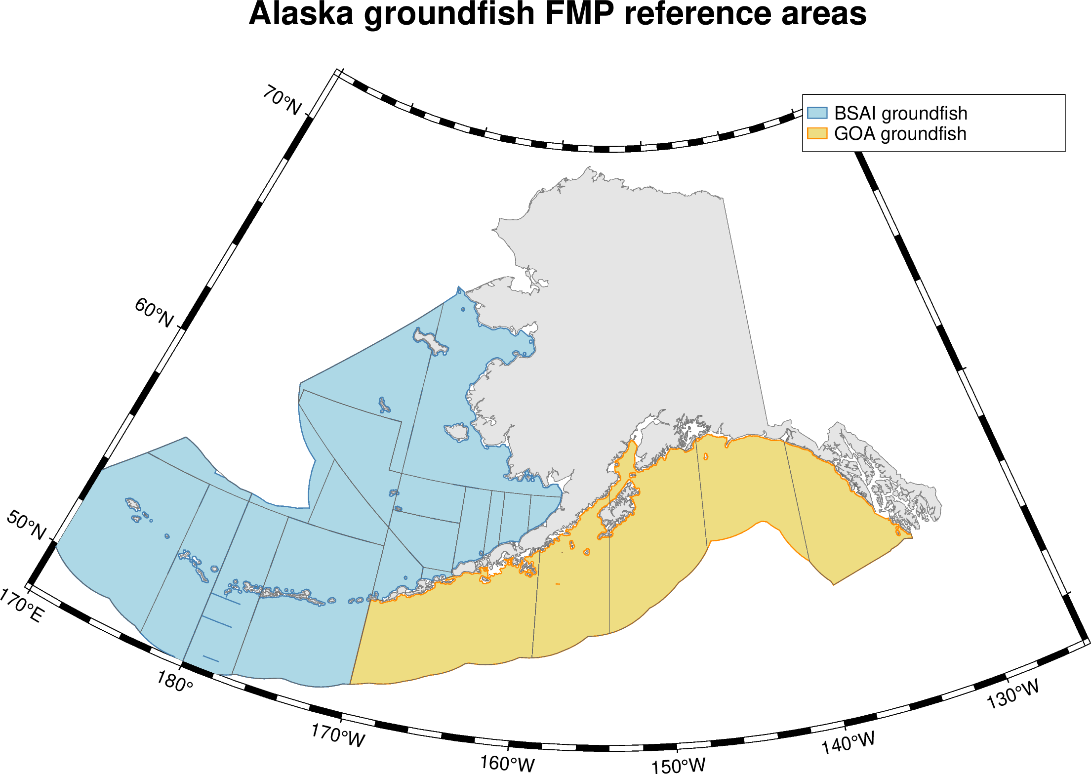
ggplot() +
  plot_fmp_areas(c("BSAI_GF", "GOA_GF"), mapping = aes(fill = fmp_id),
                 colour = "white", linewidth = 0.25) +
  plot_reporting_areas(fill = NA, colour = "grey35", linewidth = 0.15) +
  plot_coast(fill = "grey90", colour = "grey55", linewidth = 0.15) +
  coord_aksf() +
  theme_aksf() +
  labs(fill = "FMP", title = "Alaska groundfish management",
       caption = "AKsf reference geometry • NOAA / ADF&G • Natural Earth land")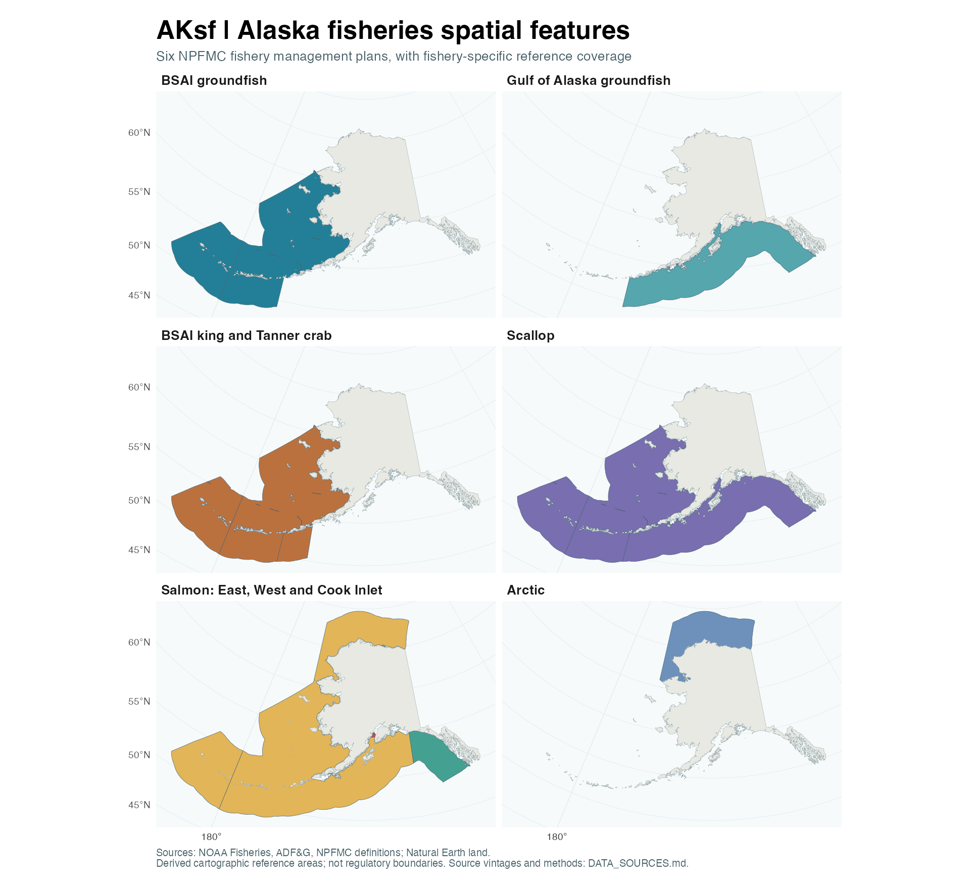
Included data
| Dataset | Contents | Access |
|---|---|---|
| NOAA/NMFS reporting areas | 25 source features; 24 codes, including 550 | get_reporting_areas() |
| ADF&G groundfish statistical areas | 1,735 six-digit areas; native hierarchy and waters codes | get_statistical_areas() |
| ADF&G groundfish registration areas | Eight letter-coded areas | get_registration_areas() |
| NPFMC FMP reference areas | Six plans; eight polygons, including three salmon areas | get_fmp_areas() |
| Alaska land | Natural Earth 1:10 million, including the western Aleutians | get_coast() |
Each spatial getter has a corresponding plot_*() helper that returns a geom_sf layer. Data are also available through data("fmp_areas"), etc. get_fmp_catalog() describes every plan; get_sources() returns the source manifest as JSON text.
Show/hide R code
ai <- get_reporting_areas(c("541", "542", "543"))
cook <- get_registration_areas("H")
stat <- get_statistical_areas()
# Preserve character codes when joining fish-ticket data:
stopifnot(all(nchar(stat$area_code) == 6L))

# Select federal polygons, not state or international waters:
federal_stat <- stat[stat$WATERS_CODE == "FED", ]

# Work in geographic coordinates when needed:
ai_ll <- get_reporting_areas(c("541", "542", "543"), proj = 4326)
Spatial closures
The NOAA spatial-closures vignette reviews habitat restrictions, Steller sea lion protections, fishery/gear layers, and inseason status sources. It includes a dated, offline GOA mapping example and GMT export, with an explicit distinction between GIS footprints and current legal closure status.
GMT and the package website
Export any bundled polygon layer with write_gmt() for use in GMT 6:
Show/hide R code
write_gmt(get_fmp_areas("BSAI_GF"), "bsai.gmt")The GMT tutorial includes an Alaska Albers map recipe, dateline handling, and guidance for environmental grids. GMT is optional; export uses sf/GDAL and retains polygon holes and agency identifiers.
A pkgdown website is configured for https://jimianelli.github.io/AKsf/. See publishing instructions for GitHub Pages activation and the difference between public documentation and package-source visibility.
Code panels on the website let you show or hide source in the articles, guides, and function examples. Select a panel’s summary, or focus it with Tab and press Enter or Space. Figures and results stay visible. The source code guide also includes package functions, data preparation, tests, and website workflows.
Eastern Bering Sea pollock maps
The survey and fishery mapping article combines bottom-trawl CPUE and temperature, AVO/ATS comparisons, shaded log values, and 2024–2026 seasonal catch. It includes nine saved figures and an offline, synthetic AKsf example. GMT supplies the bathymetry; source survey records and fishery haul extracts are maintained separately from the package. The 2026 B-season figures are partial through 18 September 2026.
Working with AFSC GAP products
AKsf overlaps substantially with akgfmaps for NMFS/ADF&G boundaries, basemaps, and plotting. Keep akgfmaps for survey strata, stations, design history, bathymetry, and detailed coastlines. AKsf adds its documented six-plan NPFMC reference catalog, source provenance, and a consistent layer interface; it does not replace the AFSC survey framework.
Use coldpool for temperature surfaces and cold-pool indices, with AKsf boundaries as management context. Use navmaps for survey-layer exports; AKsf reference polygons can be handed off as explicitly labeled GIS outlines.
See the integration guide for the overlap and added-value matrix, concrete differences between area inventories, and runnable examples. No AFSC datasets or exporters are duplicated into AKsf by these integrations.
FMP coverage
| Plan ID | Spatial representation |
|---|---|
BSAI_GF |
ADF&G federal BSAI polygons clipped to the NOAA reporting envelope |
GOA_GF |
ADF&G federal GOA polygons clipped to the NOAA reporting envelope |
BSAI_CRAB |
BSAI plus federal GOA waters west of Scotch Cap Light, per the Crab FMP |
SCALLOP |
Federal BSAI and GOA coverage combined |
SALMON |
East, West, and Cook Inlet EEZ areas; methods and source-vintage limits below |
ARCTIC |
NOAA’s published Arctic Closure geometry |
These plans are listed in the NPFMC FMP library. FMPs can overlap; summing their areas double-counts water. Halibut/IPHC regulatory areas are not an additional NPFMC FMP and are not bundled in this version.
Salmon follows the three-area structure in the October 2024 FMP, including Cook Inlet north of 59°46.15′ N. The West polygon comes from NOAA’s ATB service (last edited in 2023), with Cook Inlet explicitly removed. Its Prince William Sound and Alaska Peninsula exclusions are inherited from that source, not independently reconstructed or certified against every subsequent amendment. The East and Cook Inlet polygons are derived from ADF&G federal-water polygons.
Conventions and limits
- Default output: NAD83 / Alaska Albers, EPSG:3338, in metres. This is AKsf’s mapping default, not a universal NOAA or ADF&G source CRS. Geographic source snapshots are requested in WGS84 (EPSG:4326); datum transformations use PROJ.
- Longitudes follow the agency geographic coordinate convention. Do not crop Alaska with a naive
xmin < xmaxlongitude box across the dateline. Use the projected getters or transform your points toproj_aksf(). - Native agency fields remain intact;
area_code,area_name,authority,area_type, and provenance fields support a consistent interface. ADF&G’s registration/district/subdistrict/section/sector/statistical hierarchy is retained, not replaced by an invented universal grid. - NMFS reporting area 550 is international water and is excluded by default. Request
include_international = TRUEto include it. Reporting area 523 has two published features, both retained. Reporting polygons include some state waters and must not be treated as an EEZ boundary. - FMP geometries are derived reference maps. Source vintages differ, and retrieval date is not effective date. There is no historical-boundary query. Check current regulations for enforcement, navigation, fishing eligibility, or boundary-sensitive catch allocation.
- The Natural Earth land layer is generalized. It is not a NOAA shoreline or a baseline from which to calculate the 3-nautical-mile state-water limit.
- This first release does not bundle bathymetry, species-specific closures, crab stock boundaries, salmon district grids, or every ADF&G fishery layer.
Read DATA_SOURCES.md for methods, exact sources, known limits, and dataset licensing. The tutorial demonstrates mapping and safe spatial joins.
Rebuild and validate
Show/hide shell code
Use python3 data-raw/download.py --refresh only for an intentional source update. Object-ID batching checks completeness, and the manifest records URLs, retrieval times, feature counts, and SHA-256 checksums. Raw downloads are ignored by Git; the bundled .rda files pin the release. CI runs package checks on Linux, macOS, and Windows without fetching live spatial data.
Relationship to nzsf
AKsf follows nzsf’s R-package layout (R, data, data-raw, man, tests, vignettes) and get_*() / plot_*() pattern. It is a fresh implementation, not a renamed copy of New Zealand data or projection assumptions. The reference checkout inspected was 442c8803ea01580c3ff00062c8b02f87075922dc. Credit to Darcy Webber and the nzsf contributors for the package design.
Code: MIT. Agency and Natural Earth data have their own attribution and usage terms; see LICENSE-DATA.md.